Well we made it! Currently headed back to Phil's parents house. Today was our "easy" day. We only had 42 miles to do. We took it easy getting out of the campground (against Phil's wishes) and didn't roll out until 10:50am. We got to White's Ferry around noon expecting to stop at the little general store but it was closed up. The building was stripped of everything inside! Might have been related to recent flooding. So we continued on.
Speaking of flooding, the trail through this area was horrible! All we did was dodge puddles and mud! Some spots there was nowhere to go so you just rammed through it. It got to be pretty tricky running a bike with skinny tires loaded with weight through mud. You'd feel your bike start to sway and think "Oh no, I'm going down!" I was so glad I put that new really knobby tire on the rear! I was shocked not to see Mark go down! He was riding a road bike with skinnier tires than my bike.
We must have had about 10 miles of the mud; it really wore us out! Eventually we made it to Great Falls. This place has gorgeous views of the Potomac! You have to see the photos (see the Picasa site). They were even running canal rides in the area (canal boat pulled by mules). We stopped and got a hot lunch before moving on.
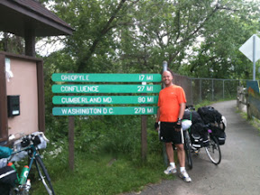
Leaving Great Falls you're heading into canal area that's heavily used so you're constantly passing. Some of it became quite boring actually. We watched the mile markers dwindle and eventually came into the Georgetown area of D.C. Phil was our guide since he's done this before. We ended up on some sidewalks and then some busy city streets. I got some pictures, but it was tough with watching traffic and changing lanes. Good thing Phil was with us, because Mark nor I would have found that 0 mile marker that quickly and easily! Got there about 5:30pm.
It was a big relief to be done! We took plenty of photos and then waited about 40 mins for our ride. Ride back to Phils was then 1hour 30 mins. Ride back to Cumberland was in pouring rain. Gonna be a long evening of getting home! Next post will likely be awhile and announce the upload of all my photos to Picasa. Perhaps I'll even do a memorable moments post with key photos.
Friday, May 27, 2011
Day 5: North Mountain to Indian Flats
Phil and I awoke to find Mark (the chef of the group) cooking up pancakes. After a good breakfast we headed to Williamsport so Phil could go to the bike shop and have his rear rim fixed. I believe we left the campsite around 9:40am.
On the way there I got a flat tire (I was due for one)! Phil went ahead to the shop and Mark stayed back to assist me. Looked like the valve ripped away from the tube so it was of course unpatchable. I had a spare tube so like a NASCAR pit crew, we tore in and got 'er done. We met up with Phil in Williamsport and headed to Tony's Pizza for lunch (was about 11:30 already). Delicious lunch and fantastic service! In fact everywhere we've ate I believe we've been offered to have our water bottles filled.
After stopping by the bike shop for me to buy a spare tube (my 2nd spare was still in Phil's car in Cumberland), we headed down the trail. Ride was a bit boring and long. Not so muddy today, but there were some washouts so bad that we had to stop and walk our bikes across.
We met a guy named Sam from London who was headed to Seattle on bike. He was going northbound to Cumberland and had about 100 miles to go at 2:00!
We had the typical road detour (where the C&O towpath has been washed out for years) for 6 miles which was a killer with hills. We also had a 3 mile section of trail where we jumped out on a paved road that paralleled the trail and used it. (No, it's not cheating!)
We rolled into Harpers Ferry around 6:30 and walked the bridge into town to look for dinner. Nothing was open in town but an ice-cream shop. Phil and Mark got some drinks and ice cream and sat around for awhile until I pointed out really dark sky coming our way. I checked the radar and sure enough a huge storm was skirting passed us and looked like we were gonna catch it. So we quickly headed back to our bikes (other side of said bridge) while we started seeing lightening. We got to the bikes and prepared for a downpour. We sat there a few minutes and watched as the storm skirted right passed us without as much as a single drop! Just as we were about to leave Diane rolled in. We exchanged hellos again, griped about trail conditions, and then we parted ways.
We got to Brunswick late, so we decided to cancel trying to get dinner there and push on to the campsite. It was getting late, so we thought we'd drop back from the planned campsite due to losing daylight. The first campsite was down a steep grade from the towpath and the next one was only 2.5 miles away anyway so we continued. That next campsite was flooded (we'd heard reports of flooded campsites from other riders) and had a sign saying closed. By this time we'd lost all our daylight and needed to go another 5.3 miles to the next campsite, the original planned stop. So with flashlight-headlights mounted we pushed on.
We finally got to the Indian Flats campsite around 10:00pm and got our tents setup. Then Mark fixed up a wonderful gourmet smorgasbord of leftover foods for he and I while Phil ate. Poptart and went to bed. (Phil's knee has been bothering him the entire ride.)
Tomorrow is our final day and we should easily finish. Our ride home is available at 6:00, so we might even have time to kill in Great Falls or Georgetown. We now only have 44 miles to go!
By the way, again I have been able to upload a few more photos (from Harpers Ferry) to my Picasa site.
Thursday, May 26, 2011
Day 4 Cumberland to North Mountain (McCoys Ferry)
Well today was kind of rough. We did get a decent nights sleep and did laundry at the hotel last night. We ended up getting a late start today (10:40). Mark had to go over to the bike shop and get his squeaking bike checked out (just across from hotel). We also had to share a bathroom to get ready. Oh, and we all had stuff to drop-off and pickup at Phil's car.
So we rolled out of Cumberland and started down the C&O canal towpath. Let me tell you, the C&O canal makes the Great Allegheny Passage seem like an interstate highway! The canal towpath is in much rougher shape and doesn't drain the rainwater away, so most of the day was spent dodging mud puddles. Our bikes still got pretty muddy. Due to the late start we didn't have an official lunch break, just ate during our 5 minute breaks.
We got to the Paw Paw tunnel and stopped for some photo ops. Again, the flashlight headlight system worked well for getting through the 3,000+ foot tunnel (although I left my sunglasses on in the tunnel for the first few hundred feet wondering why my flashlight wasn't so bright - no joke).
On the other side of the tunnel we met a young couple from North Carolina doing the entire trip from D.C. to Pittsburgh. Oh, I should also mention that we've met a young lady named Diane riding by herself the same direction as us. We keep leapfrogging her. We met her just before Rockwood, PA.
Hancock was our next goal - dinner out. We hooked up with the Western MD Rail-Trail at mile marker 136 and rode a wide paved trail into Hancock (and out of Hancock to mile marker +/- 116 - 20 miles). This was one awesome trail you could make some serious time on!
Before long though we found that Phil's rear tire was coming more and more out of true and would need attention very soon. He could feel it wobbling as we rode now. Mark decided to blast ahead down the trail and try to catch the bike shop open in Hancock. I stayed back with Phil and we met up with Mark in front of the bike shop at 7:20 - shop closed at 6!
We had to make some decisions on what to do. First we looked Phil's rear wheel over and found a bunch of loose spokes and one broken spoke. So we tied up the broken spoke and tightened the loose ones. Phil test rode and decided he could make the bike shop in Williamsport (mile marker 100) the next morning.
We were planning a nice sit down meal since it was likely our last opportunity before D.C., but decided to settle for Sheetz to try and get going toward our destination before dark. Well the guys had to stop at the Dollar General and Sheetz took forever with our food, so we didn't get out of Hancock about 8:45.
We continued on the Western MD Rail-Trail about another 6 miles and it quickly became very dark (it's tree-lined). So this again was another opportunity to use my flashlight headlight mounts. This worked out great; I could dimly light up the entire width treelike to treelike (about 30 feet) and spot a brighter beam ahead about 300 to 400 feet ahead. I was using my 3 watt LED "People's Cree" light which only runs on 3 AAA batteries. I left it on for an hour and a half as we rode in darkness.
At mile marker 116 we had to drop back down to the C&O canal and go 6 miles on that. This was nowhere near as fun in the dark and quite spooky. We finally reached our destination of North Mountain campsite (a typical hiker-biker campsite) near McCoys Ferry at 10:30pm. We had already eaten dinner so all we had to do was setup our tents, no easy task on the dark!
So there you have day 4! 74.5 miles in one day with a late start! I must apologize, as it seems I can't get any photos uploaded again. Apparently it's only working when I'm on a WiFi connection. Sorry for that, I really wish I could have added photos to this entry!
Tomorrow should take us about 64 miles (we're 6 miles ahead of the original itinerary) to the Indian Flats hiker-biker campsite.
EDIT- I was able to upload a few photos to my Picasa website in the "During the Bike Trip" folder again. I uploaded the 0 mile marker for The Great Allegheny Passage and some photos of the Paw Paw tunnel.
Wednesday, May 25, 2011
Days 2 & 3 Dravo to Cumberland, MD
First of all I want to apologize to my followers for not posting a blog entry last night. It's not that I didn't try, but that I didn't have cell service in Confluence in order to post. So I'm gonna cover days 2 & 3 in this post.
Day 2 we left the Dravo cemetery campground around 9:20am. We rode into West Newton and stopped at a Rite Aid for Phil & Mark to get some supplies/food. Phil's knee has been bothering him, so he got some IcyHot and has been using that stuff nonstop since.
From West Newton we then rode to Connellsville for lunch stopping at the Martins. Mark likes to ride ahead, so Phil told him to stop at the Martins he couldn't miss it. Well wouldn't you know he rode on past! To Mark's defense, you can't tell it's Martins because you're riding into the backside of it so it looks like any other large building. Phil & I went in, got food, and eventually Mark found us. We only wanted to stop for a half hour, but it turned into a full hour.
We stopped at the end of town and took some photos at a mile marker and took notice of a warning to watch out for mountain lions! Here's the mile marker:
So we started heading on our way and not too long thereafter I spotted something furry looking in the trail ahead. Phil & I were riding side-by-side ahead of Mark and I said "do you see that?", hit my brakes, and came to a halt. Phil said "yeah" and stopped. Then Mark rode up and stopped. We realized it was a large black bear! We were about 600 feet away and just watched. The bear would look at us, walk around as if looking for something else, and then look back at us. After about a minute or so it went up into the woods. We gave it another minute or so and then rode by. I tried to get pictures (with my real camera-don't have them to upload), but I'm not sure you'll be able to make out the bear very well.
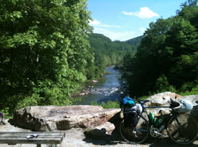
We then came upon a beautiful scenic spot overlooking the Yough river and stopped for a photo op:
We made it to Ohiopyle and stopped for about an hour for a rest and to look around. Finally we left Ohiopyle and headed for Confluence - our destination. We rolled in just after 7pm and setup camp. We actually setup before dark! Mark has taken the role of cook and whipped up some chicken and mashed potatoes complete with gravy.
We stayed at the Outflow Campground (commercial) and so we had shower facilities. It sure feels good to get a shower after a long day of riding!
During the night we had a huge wind storm roll in and I thought my tent was going to liftoff! Then in the early morning we had rain.
Day 3: Got up early - about 6:30 - and got packed up quickly. We ate breakfast in town at Sister's Cafe and got started riding about 8:40. When we got to Garrett we picked up a stash of water and power bars that I placed there on Friday (I was working only 5 miles away from the trip). We didn't tell Mark about this drop off and he was wondering what the heck was going on when I stopped and walked behind some trees for a "hidden water hole".
We then pushed on to Meyersdale for lunch. We stopped at the Sheetz in town. While eating there outside up pulls one of my company's vehicles! (Weird!) We were then about to leave and found Phil's tire flat! So we lost another 30 minutes patching his tube.

So we then finally left Meyersdale and headed up the climb to the highest point on the trail at Deal, PA. We enjoyed the views from the top and the Big Savage Tunnel. As we started down the mountain we found Mark's tire flat! So we lost another 30 minutes! We then flew down the mountain (it drops about 1800 feet in 20 miles) and arrived in Cumberland at 7:00. For dinner we met up with an old friend of mine, Nate, and ate at CiCi's.
In Cumberland we are staying at a hotel for a good nights sleep and showers. I was able to upload some photos to my Google Picasa site and I'm storing then in a "During the Bike Trip" folder. I'm not using my phone's camera much so you'll have to wait for more photos after I get home and upload them from my camera.
I'm not sure how cell reception will be on the C&O, but I will try to keep you updated!
Day 2 we left the Dravo cemetery campground around 9:20am. We rode into West Newton and stopped at a Rite Aid for Phil & Mark to get some supplies/food. Phil's knee has been bothering him, so he got some IcyHot and has been using that stuff nonstop since.
From West Newton we then rode to Connellsville for lunch stopping at the Martins. Mark likes to ride ahead, so Phil told him to stop at the Martins he couldn't miss it. Well wouldn't you know he rode on past! To Mark's defense, you can't tell it's Martins because you're riding into the backside of it so it looks like any other large building. Phil & I went in, got food, and eventually Mark found us. We only wanted to stop for a half hour, but it turned into a full hour.
We stopped at the end of town and took some photos at a mile marker and took notice of a warning to watch out for mountain lions! Here's the mile marker:
So we started heading on our way and not too long thereafter I spotted something furry looking in the trail ahead. Phil & I were riding side-by-side ahead of Mark and I said "do you see that?", hit my brakes, and came to a halt. Phil said "yeah" and stopped. Then Mark rode up and stopped. We realized it was a large black bear! We were about 600 feet away and just watched. The bear would look at us, walk around as if looking for something else, and then look back at us. After about a minute or so it went up into the woods. We gave it another minute or so and then rode by. I tried to get pictures (with my real camera-don't have them to upload), but I'm not sure you'll be able to make out the bear very well.
We then came upon a beautiful scenic spot overlooking the Yough river and stopped for a photo op:
We made it to Ohiopyle and stopped for about an hour for a rest and to look around. Finally we left Ohiopyle and headed for Confluence - our destination. We rolled in just after 7pm and setup camp. We actually setup before dark! Mark has taken the role of cook and whipped up some chicken and mashed potatoes complete with gravy.
We stayed at the Outflow Campground (commercial) and so we had shower facilities. It sure feels good to get a shower after a long day of riding!
During the night we had a huge wind storm roll in and I thought my tent was going to liftoff! Then in the early morning we had rain.
Day 3: Got up early - about 6:30 - and got packed up quickly. We ate breakfast in town at Sister's Cafe and got started riding about 8:40. When we got to Garrett we picked up a stash of water and power bars that I placed there on Friday (I was working only 5 miles away from the trip). We didn't tell Mark about this drop off and he was wondering what the heck was going on when I stopped and walked behind some trees for a "hidden water hole".
We then pushed on to Meyersdale for lunch. We stopped at the Sheetz in town. While eating there outside up pulls one of my company's vehicles! (Weird!) We were then about to leave and found Phil's tire flat! So we lost another 30 minutes patching his tube.
So we then finally left Meyersdale and headed up the climb to the highest point on the trail at Deal, PA. We enjoyed the views from the top and the Big Savage Tunnel. As we started down the mountain we found Mark's tire flat! So we lost another 30 minutes! We then flew down the mountain (it drops about 1800 feet in 20 miles) and arrived in Cumberland at 7:00. For dinner we met up with an old friend of mine, Nate, and ate at CiCi's.
In Cumberland we are staying at a hotel for a good nights sleep and showers. I was able to upload some photos to my Google Picasa site and I'm storing then in a "During the Bike Trip" folder. I'm not using my phone's camera much so you'll have to wait for more photos after I get home and upload them from my camera.
I'm not sure how cell reception will be on the C&O, but I will try to keep you updated!
Monday, May 23, 2011
Day 1 - Duquesne to Dravo Cemetery Campground
Well the day finally came! The weekend was a mad rush to get packed, organized, and driving around picking people up, but here we are at the end of Day 1 at The Dravo Cemetery Campground! We had no trouble at all getting dropped off at Grant Ave in Duquesne. We were running behind schedule so we didn't actually start our trek until 8:05pm. We knew we couldn't make the campground by dusk, so the flashlight headlight setups became essential!
At first I was very much concerned about the amount of weight I was putting on my rear rack. So far so good though. I will say one thing though, I forgot what it's like to ride a loaded bike! You make one false move that throws you off balance and you're going down! It's a very weird feeling riding with all that weight loaded and feeling it start to cause your bike to move ways you don't expect.
The ride though McKeesport was nothing special at all, in fact you ride through the projects (not an area to ride after dark) and are on the road much of the time. When you do have a designated trail it's paved.
We came through the town of Boston around dusk and basically headed into the wilderness setting from there. Here is where the flashlight headlight setup came into play and I was in no way disappointed! Except for the fact that on the front of my bike on my front rack is my sleeping bag which is inside of a very reflective dry sack. This sits high enough on the rack that it interferes with the flashlight, so I got a lot of reflected light back in my face at times. (I probably looked like a ghost coming down the trail!)
I kept telling myself tonight was only 13 miles and so I just had to bare with any discomfort. I chose not to wear bike shorts since this trek was so short. I'm feeling it though!
Camp setup went well, although a little rough in the dark with flashlights. We arrived at about 9:20pm. There are at least two other parties here as well, though we haven't had any contact with them. This campground is nice; we have picnic tables all around, tent pads spaced out, a fire ring, a bathhouse (no running water), and a water pump. We are situated about 300 feet of the Yough river.
Tonight we made a fire and had hot dogs, beans, and s'mores. It very quickly became 11:00pm and so Phil and Mark hit the hay (party-poppers!). It's almost midnight now and they're saying they want to leave by 9am, so I need to get to bed as well. But before I leave here are a few photos taken before dark:
Ok, it seems I don't have enough signal to get the pics uploaded! I'll try again tomorrow. And keep an eye out on my Picasa site too- I'll see if I can upload them there (that web address is in a previous post).
Goodnight!
Tuesday, May 17, 2011
Not Ready Yet!
Well we only have a few days left until we start this adventure and I feel nowhere near ready! I haven't been able to get any more riding in due to horribly rainy weather and responsibilities at home.
I still don't have my bike completely ready. I still need to degrease the drivetrain and re-lube. I also haven't tested the rack with much weight on it. I did test the fit of the panniers and sprayed all my bags down with silicone spray. I still have to do a final shopping trip for food and supplies.
Last week I did get my tent out, seam sealed it, and aired it out (hasn't been used in about 13 years). I had a scare though. When I went to pack it away one of the shock cords snapped in the tent poles! I had to quickly lookup how to repair/replace these cords. And would you believe no store in the Johnstown area sells replacement shock cord long enough? I had to order it on Amazon. However I didn't know how quick it was going to show up and if I'd have the time to replace it, so I ended up doing a quick repair of the existing cord. I'll carry the new cord in case it's needed. Here's a picture of my tent (nothing fancy):

Well, I better get going. I have a lot to do to be ready! The next post will likely be the first night of the trip. Toodles!
I still don't have my bike completely ready. I still need to degrease the drivetrain and re-lube. I also haven't tested the rack with much weight on it. I did test the fit of the panniers and sprayed all my bags down with silicone spray. I still have to do a final shopping trip for food and supplies.
Last week I did get my tent out, seam sealed it, and aired it out (hasn't been used in about 13 years). I had a scare though. When I went to pack it away one of the shock cords snapped in the tent poles! I had to quickly lookup how to repair/replace these cords. And would you believe no store in the Johnstown area sells replacement shock cord long enough? I had to order it on Amazon. However I didn't know how quick it was going to show up and if I'd have the time to replace it, so I ended up doing a quick repair of the existing cord. I'll carry the new cord in case it's needed. Here's a picture of my tent (nothing fancy):
Well, I better get going. I have a lot to do to be ready! The next post will likely be the first night of the trip. Toodles!
Monday, May 9, 2011
Planning the Trip - Itinerary
I keep saying that we are planning to do this trip in 6 days, but in reality it's more like 4 1/2 to 5 days. You see day 1 is simply driving out to the western end of the Great Allegheny Passage (in Duquesne, just outside of Pittsburgh), getting dropped off, loaded up, and then riding to the first campground - Dravo Cemetery Campground about 13 miles (1 to 1 1/2 hours of cycling). We then have 4 solid days of cycling and about a half day left on day 6.
As mentioned in my first post, I am riding with 2 other guys - Phil & Mark. Phil is a longtime friend who currently lives in Martinsburg, WV (although moving to Hagerstown - aka. "Hagertucky" - in the very near future). Mark is one of Phil's friends and roommates who I've never met. Phil describes him as an "avid outdoorsman" who could catch fish with his bare hands or cook a mean steak on a campfire. He's also quite a bit younger than Phil & I (ie. in better shape). Phil has ridden the Great Allegheny Passage & C&O Canal towpath in past years. Last Spring he completed the ride from Boston (outside of Pittsburgh) to D.C. The Fall prior he attempted the entire trip, but stopped early at Paw Paw (about 27 miles south of Cumberland) due to bad weather and bike problems.
We are starting this adventure Sunday May 22nd and ending on Friday May 27th. But before I move on to more details, here are the two maps to follow along (you should be able to click the image and see a clearer larger version):


(If these maps are not clear, see the following links: Great Allegheny Passage and C&O Canal Towpath.
Day 1 (Sunday May 22nd)
As mentioned above, day 1 is mostly just getting out to Pittsburgh and getting started. Phil and Mark will have the task of getting Mark's truck to Phil's parents house (about 1 hour north of D.C. in Mt Airy, MD - it's actually on the above map). Phil and Mark will then drive to Cumberland where I will be meeting them to pick them up. The intention is to leave Phil's car somewhere where we can utilize it for a drop-off / pickup location for clothes, supplies, etc. . . I will then drive Phil and Mark back to my house (Nanty Glo, PA) where I will load up my bike and supplies. My father-in-law (or possibly a fill-in) will then ride along with us to Pittsburgh (Duquesne - just south of the Kennywood amusement park - trail mile marker 135) in order to drive my car back home. The plan is to leave my house around 5pm in order to get dropped off in Duquesne by 7pm so that we can ride the 13 miles to Dravo Cemetery Campground - trail mile marker 122 - before sunset (Phil says the old people come out of their houses and yell at you for being on the trail after dark). This campground is a nice one maintained by the Boy Scouts. See it in Bing Bird's Eye View by clicking here.
Day 2 (Monday May 23rd)
Plan is to ride from Dravo Cemetery Campground (trail mile marker 122) 60 miles to the Outflow Campground (commercial campground) in Confluence, PA - trail mile marker 62 - with a stop for lunch in Connellsville, PA - trail mile marker 88. Campground seen here.
Day 3 (Tuesday May 24th)
Plan is to ride from Outflow Campground in Confluence, PA - trail mile marker 62 to the end of the Great Allegheny Passage and start of the C&O Canal Towpath in Cumberland, MD - mile marker 0 (G.A.P. trail) and 184.5 of the C&O Canal. We are planning to stay at the Fairfield Inn which is located right along the trail. Here we can use the laundry facilities, hot tub, swimming pool, etc . . . And as mentioned we can also get to Phil's car to drop-off / pickup supplies. We may also have a visit from longtime friend Nate (Nate-dog) Elliott.
Day 4 (Wednesday May 25th)
As mentioned in my first post, I am riding with 2 other guys - Phil & Mark. Phil is a longtime friend who currently lives in Martinsburg, WV (although moving to Hagerstown - aka. "Hagertucky" - in the very near future). Mark is one of Phil's friends and roommates who I've never met. Phil describes him as an "avid outdoorsman" who could catch fish with his bare hands or cook a mean steak on a campfire. He's also quite a bit younger than Phil & I (ie. in better shape). Phil has ridden the Great Allegheny Passage & C&O Canal towpath in past years. Last Spring he completed the ride from Boston (outside of Pittsburgh) to D.C. The Fall prior he attempted the entire trip, but stopped early at Paw Paw (about 27 miles south of Cumberland) due to bad weather and bike problems.
We are starting this adventure Sunday May 22nd and ending on Friday May 27th. But before I move on to more details, here are the two maps to follow along (you should be able to click the image and see a clearer larger version):
and The C&O Canal:
(If these maps are not clear, see the following links: Great Allegheny Passage and C&O Canal Towpath.
Day 1 (Sunday May 22nd)
As mentioned above, day 1 is mostly just getting out to Pittsburgh and getting started. Phil and Mark will have the task of getting Mark's truck to Phil's parents house (about 1 hour north of D.C. in Mt Airy, MD - it's actually on the above map). Phil and Mark will then drive to Cumberland where I will be meeting them to pick them up. The intention is to leave Phil's car somewhere where we can utilize it for a drop-off / pickup location for clothes, supplies, etc. . . I will then drive Phil and Mark back to my house (Nanty Glo, PA) where I will load up my bike and supplies. My father-in-law (or possibly a fill-in) will then ride along with us to Pittsburgh (Duquesne - just south of the Kennywood amusement park - trail mile marker 135) in order to drive my car back home. The plan is to leave my house around 5pm in order to get dropped off in Duquesne by 7pm so that we can ride the 13 miles to Dravo Cemetery Campground - trail mile marker 122 - before sunset (Phil says the old people come out of their houses and yell at you for being on the trail after dark). This campground is a nice one maintained by the Boy Scouts. See it in Bing Bird's Eye View by clicking here.
Day 2 (Monday May 23rd)
Plan is to ride from Dravo Cemetery Campground (trail mile marker 122) 60 miles to the Outflow Campground (commercial campground) in Confluence, PA - trail mile marker 62 - with a stop for lunch in Connellsville, PA - trail mile marker 88. Campground seen here.
Day 3 (Tuesday May 24th)
Plan is to ride from Outflow Campground in Confluence, PA - trail mile marker 62 to the end of the Great Allegheny Passage and start of the C&O Canal Towpath in Cumberland, MD - mile marker 0 (G.A.P. trail) and 184.5 of the C&O Canal. We are planning to stay at the Fairfield Inn which is located right along the trail. Here we can use the laundry facilities, hot tub, swimming pool, etc . . . And as mentioned we can also get to Phil's car to drop-off / pickup supplies. We may also have a visit from longtime friend Nate (Nate-dog) Elliott.
Day 4 (Wednesday May 25th)
Plan is to ride from Cumberland, MD - mile marker 184.5 - to the "Licking Creek Aqueduct" campground (rustic campground) located about 7 miles south of Hancock, MD at trail mile marker 117. Now that I look at the map I see this campsite is very close to I-70, so we're thinking to push on another 7 miles to the "North Mountain" Campsite near McCoy's Ferry - trail mile marker 110. In the Hancock area we plan to utilize the 20+ mile long Western Maryland Rail Trail as a bypass to this section of the canal (it's paved and nicer).
Day 5 (Thursday May 26th)
Plan is to ride from the "North Mountain" Campsite - mile marker 110 - to the "Indian Flats" campsite at trail mile marker 43.
Day 6 (Friday May 27th)
Plan is to ride from the "Indian Flats" campsite at trail mile marker 43 the remaining distance to mile marker 0 in Georgetown (D.C.). We should arrive in D.C. mid to late afternoon in good time to be picked up by one of Phil's friends and driven back to Phil's house. At Phil's house we switch into Mark's truck and Mark drives to Cumberland where Phil will get his car and I will get picked up by my Father-In-Law. I don't doubt it will be close to midnight before I get home!
There you have it! You know as well as I do that things probably won't go as planned. If we do get held up for some reason we do have Day 7 (Saturday May 28th) to finish the trip if needed. And camping along the C&O canal is much more flexible. The rustic campsites are spaced out about every 7 miles above mile marker 26 (there is no camping below mile marker 26).
I usually give you an idea of what my next blog entry will be along with a title, but I am unsure what it will be at this time. You'll just have to stay tuned!
Wednesday, May 4, 2011
Preparing My Phone
Well for those of you who don't know already, my wife and I got new phones. Not only did we get new phones, but we also switched carriers. We were with Verizon (for about 10 years) and the location of our new house has very weak signal for Verizon. We spoke with them and they didn't seem too interested in helping us. They did have at least one option for us, but weren't too interested in keeping our business so they didn't make it affordable for us. We then spoke with AT&T, which we knew had full signal at our new house, and they gave us tons of incentives to switch including 2 new iPhones (the 3GS version). Along with the incentives, we are now on a data plan (ie. internet), so we have a lot more capability with our phones that we never had before.
Enter the world of "apps". You know the saying, "there's an app for that". Well in preparation for this trip I have found and installed a GPS mapping app (yes, the iPhone has a GPS receiver built-in - just like many phones) called "MotionX GPS" (found here: http://gps.motionx.com/iphone/overview/). This software shows your GPS position, allows you to store "waypoints", navigate to stored points, etc . . . just like your typical handheld GPS receiver, except that it can also download and show you your position on a topo map (terrain map), aerial photo, or road map pulled down from Google, Bing, or MotionX. Of course you'd have to be concerned with your data usage (unless you are on an unlimited plan), so you are also given the option of downloading and storing the MotionX maps (which are terrain or road maps from an open source) for offline use. I have gone ahead and downloaded the terrain maps which cover our entire trip from Pittsburgh to D.C. (about 2 GB's of data). Now I don't plan on using the GPS software that often, but I thought it could be really handy to have, especially in an emergency.
Here are a few screen captures from the software on my phone:
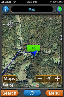

Basic Position Screen

Position Shown On the Open Source Terrain Map (elevations are in meters)

Position Shown On Bing Aerial Photo
Of course there are other cool features having an iPhone. One of those is that photos taken with it's camera (not every camera app, but at least with the supplied app) are "geotagged" (see: http://en.wikipedia.org/wiki/Geotagged_photograph). This means the lattitude & longitude of the photo's location are stored with the photo. Most of my photos on this trip will be taken with a digital camera and not my phone, so I won't have coordinates for many of them. I do intend to keep my phone off most of the time in order to conserve battery power. I will try to take enough photos with my phone to have some to post to the blog during the trip.
Other apps that I have acquired in preparation for this trip include an app to write & upload my blog entries and an app to upload photos to my Google Picasa Web Album (found here: http://picasaweb.google.com/108300668976745126881). The blog app will upload photos, but it shrinks them and doesn't give me any control over the resizing. The Picasa Upload app allows me to choose what size I want to upload inlcuding the full original size. By the way, that Picasa Web Album location is where I will be uploading all of my trip related photos. I can't put every photo from the trip in the blog! Of course many photos won't get uploaded until the trip is over. I will probably post one last blog entry that I have uploaded all of the photos.
Well that about covers it on the phone preparation. I only have a few weeks before the big trip so I need to get to moving on posting the actual trip plans (where we plan to stay, how far we're going each day, etc. . .). So stay tuned for the next blog entry, "Planning the Trip". Until then, papa fritas!
-Garry
Subscribe to:
Posts (Atom)